Quantcast
Channel: Wolverton Past - History before 1970
Viewing all 211 articles
Browse latest View live

The "Manor" of Chicksand Priory

$
0
0
The Chicksand Priory at Dunstable was founded around 1150 during that high energy period when there was a rush to establish monastic settlements by the second and thrid generation families of the Norman conquerors. Chicksand was the project of Roais, wife of Payn de Beauchamp, Baron of Bedford and former wife of Geoffrey de Mandeville, Earl of Essex. Thus there was plenty of money behind Chicksand and it was well endowed from the first, unlike Bradwell Priory, founded at about the same time, which started and continued with meagre resources. It is reckoned that Chicksand may have supported as many as 100 monks and nuns in the early years of the 13th century.

Its connection with Wolverton was that at some time in the 12th or 13th century it acquired some land in Wolverton, which it subsequently referred to as its manor of Wolverton. There are no records in the Wolverton documents aout its purchase or subsequent sale, nor do we know how much land it acquired  or its precise location. There are some deeds from the late 13th century which make reference to parcels of land next to the land of the Prior of Chekesande or abutting the land of the Prior of Chekesong and both of these are de le Est, meaning in the east of the manor. One might guess that this was in the region of Stonebridge House Farm, but we would not get any more precise than that. It could equally be in the Bancroft area.

The Priory of Chicksands overreached itself. They acquired too much property and too many debts and in 1325 they had to forfeit the Wolverton land to a "merchant of Genoa" as part payment of their debts - which were huge. It is not known what the merchant of Genoa did withthe land. He must have sold it quickly because had he kept it for some time it might well have acquired a name associated with him. It is likely that it was sold back to the de Wolvertons. Later 14th century documents were still referring to it as the land of thePrior of Chekesond.


Further information about Chicksand Priory can be found here. http://www.chicksandspriory.co.uk

Wolverton's Grand Houses II

$
0
0
In an earlier post I wrote about the tiny number of large houses that were ever built in Wolverton. Since then I have come across some new information about the manor house at Wolverton built by Sir Henry Longueville in 1586.

In the early part of the 18th Century, Sir Edward Longueville, faced with a mountain of debt, resolved to sell the Wolverton estate. We know that in 1713 he succeeded in this by completing a sale to Dr. John Radcliffe for £40,000. What I did not know was that there was earlier interest from the Duke of Newcastle and there are a number of documents now kept in the Nottinghamshire Archive which show that the Duke's interest was serious as many details of the estate, the rents, the value of properties, potential taxes were set down together with a number of questions that needed an answer. In the end the Duke decided to offer £30,200 in the year 1710. This was unacceptable to Sr Edward and since the Duke died the following year in 1711, I imagine that negotiations did not continue.

The Wolverton historian can find a great deal of good information in these documents and here I am going to concentrate on what we can learn about the house.

Of the earlier buildings we know next to nothing. It is probable that the Longuevilles improved and enlarged the earlier medieval property during the 15th century. The only reference we have to the building is from the Tudor traveller and writer John Leland, who was passing through around 1540.
The Langevilles of later tymes hath lyen and bilded fairly at Wolverstun in Bukinghamshie (nere Stony Streatford).
We can only interpret "bilded fairly" as that the house was of sufficient size for Leland to take notice.

Later in the century Sir Henry Longueville decided to embark on his own building project at a cost of £12,000 - a very significant sum of money. This was in 1586. Once again we are short of any drawing or description until Thomas Hearne, writing in 1711 tells us this much:
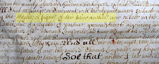
It stood near a large mount, thrown up East of the Church, & it was a magnificent Edifice, being 145 Feet in length & built with good Free-stone. It had 9 large transome windows in the Front, of good polished Free-stone which was very regular; it had in the first Range a spacious lofty Kitchen, Buttery, Hall & Great Parlour, in which last room were painted in the large Escucheons (sic), the Arms of the Longueville Family with their matches quartered & impaled. There were also some arms in the windows of painted glass; particularly of Wolverton & Roche: the first of which bore, B. an Eagle displayed A determined by a Bendlet  G. K. the other, viz. Roche, gave G. 3 Roaches A.  This front part, as seems to me, built by Sir Hen Longueville in Queen Elizabeth's time: and Sir Henry & his lady Elizabeth Cotton's Arms, being placed there in 2 Shields, with this date, 1586, seems as if they were the builders, and that it was begun to be built then; it cost, as I have been informed, above 12 thousand pounds in those days. At each end were several Rooms of an antient tower structure, which were chiefly made use of, & particularly those on the south wing, by Sir Edward Longueville. I visited him in 1711: & several rooms in the new building were never finished, or properly furnished, as appeared to me.(Theses notes made by William Cole a century later.)
The document in the Nottinghamshire archive is able to offer us supporting detail.
The House is 60 yards in front with two Wings about 15 yards in lenght (sic). Built of Stone is very Strong & in perfect good repair. The Gallary which is a very noble one, the floore was never layed down, all offices that are necessary as Wash houses, Brew house, dary house, larders, Granarys, Wood Barns, Stables for 20 horse, Coach House with 20 Bay of Barning with a Worke House, two Duffcoates & several Houses very necessary for any use in good repair.
We can read from this that the house was stone built with a frontage of 180 feet (Hearne says 145) with two wings at each side of 45 feet. It is not clear which of the "offices" are included in the wings of the great house but it is probable, given the size of the stables and coach house, that this building and almost certainly the dovecotes are separate structures. From Hearne's description we might infer that the kitchen and buttery (larder) made up one wing of the building. I am guessing that a second floor gallery was designed around either the hall or the "great parlour" but that this floor was never completed, although this phrase never layed down is open to different interpretations.

The photograph below is a survivor from that period of Elizabethan building. It was built in 1572 at Trerice in Cornwall and is considered a small house of its type. I am posting it here to offer some general idea of how the Longueville house may have appeared.


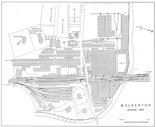
 When Hearne talks of a south wing we might read into that an eastern or south-eastern frontage for the house, possibly parallel with the course of the Old Wolverton Road. The location of the house may have been that piece of level ground opposite the Rectory, in other words between the present Rectory and the old castle mound.


Hearne's observations are probably accurate but his interpretations can be modified. the window with the date of 1586 is more likely to have been the completion date rather than the date building began; the windows are usually the last part of house building. His observation that the greater part of the building seemed unfurnished may have more to do with Sir Edward's straitened circumstances than the fact that the building was not completed and that he had been selling off furniture to pay debts and was confining himself to one wing of the building. £12,000 was an enormous sum of money to spend on a house in Elizabethan times, and even if that sum had been exaggerated, there should have been plenty of money to complete the building to the satisfaction of Sir Henry and his wife.

We are told in the Nottingham Archive document that the building was strongly built, which doen't quite square with the fate of the building in 1726. It is impossible to say who wrote this document. If it had been prepared by one of Sir Edward's men as a prospectus then a certain amount of puffery might be expected. In any event, only a few years later, the Radcliffe trustees took a different view. In a letter dated 24th October 1715 William Bromley (one of the Trustees) wrote in a letter that the Great House was:
very ruinous, & since it is now never likes to be used as a Gentleman's Seat you'l consider whether it may not be advisable that it be taken down, & the materials disposed of.
Many of the buildings on the estate were in poor state of repair and when it came time to rebuild the Rectory this course of action recommended itself to the Trustees. Parts of the old mansion can be found in the Rectory which is still standing today.


A possible date for The Bull at Stony Stratford

$
0
0

Documents that refer specifically to The Bull begin to appear in the late 17th century. These have been noted in the Hyde-Markham book on the History of Stony Stratford in the appendix. From that time the Bull is fairly well documented but because of its destruction by fire in 1742 there is no way of identifying an earlier building until some archaeological work is undertaken on the foundations.

Marion Hyde's map of Stony Stratford circa 1680, drawn over 50 years ago and much reproduced, shows a date of 1609 against The Bull. I cannot trace any documented reference to this date unless it is in one of the several versions of Michael Hipwell's will and I have missed it. The date 1609 most probably comes from that source. I should also note at this point that the same map suggests a date of 1480 for the Rose and Crown. This does fit in with the belief that many people held 50 years ago that the inn was there when the two Princes were abducted by Richard of Gloucester in 1483. Modern research is less supportive of that idea today.  Much of the present building at 26-28 High Street  is 18th century although it does contain some 16th century elements.

Back to a date for The Bull. I have come across this document in the Nottinghamshire Archives which was prepared in 1710 for the prospective sale of the Wolverton Manor.
The Bull Inn has been lett for as much this 80 years, no land about the Town of Stoney Stratford but what letts for forty-fifty shillings an Acre, when any to left; several are Courting for it their being not Ground anough to supply the Occasions of ye Towns people.
The italics are mine, but this figure allows us a start date of 1630. By comparison the same writer refers to the Three Swans inn has been lett time out of mind. We know that at the very minimum the Swan  was in business in 1526 when it appears in Bradwell priory records, and Browne Willis in the 18th century was of the view that it was this inn where the royal party were staying in 1483. (I have discussed this question in an earlier post.)

If we take this reference as an approximate foundation date for The Bull Inn this does raise the question of what may have been there before? The medieval burgage plots (long strips of land going back from the Watling Street) do continue southwards to approximately where New Street now sits, so there would have been something on the site of the Bull. Was it an inn under a different name? Possibly.

However the innholder lists of 1577 indicate that there were 4 innholders on the east side. If, as I argued in my earlier post about 1577 innholders. we take the Cock, The Three Swans, the Red Lyon as three we know were there in the 16th century and we accept the Rose and Crown as the fourth, then there would have been no place for the Bull in that list - which may support the idea that it was indeed a 17th century foundation.

Nothing is absolute here, but on the basis of what I have showed, you could make a case for The Bull  dating back only to 1630

The Angels of Stony Stratford

$
0
0
From the north, the first house on the right was The Barley Mow
For a period there was a trend, almost amounting to a craze, to name inns and alehouses The Angel. Quite what prompted this is unclear but there was a period when there was an Angel at the north end of the High Street and another at the south end, causing one wag to observe that Stony Stratford was protected by angels at both ends.

There is a long history of an inn on the site of the Barley Mow going back to the 14th century when it was called Grik's Herber (The Greek's Auberge). We are not told the location in the deed of 1317 but we an infer it from 17th century documents which locate this parcel of land here and call it "Gregg's Arbour". Being on the west side it was part of the Calverton manor but during the 13th century, when there were a number of disputes between the de Veres and the de Wovertons, Sir John de Wolverton acquired a strip of land on the west side to safeguard his market tolls.

It was on record as The Angel in 1677 but by 1770 it was known as The Barley Mow - a name it kept until it was converted to a private residence. It is quite possible that its tenure as The Angel did not last long. At the time the manor changed hand in 1713, Gregg's Arbour was "in Sir Edward's hands" and in succeeding years it was leased by one of the millers, with mooring rights. So while there has been a long history of an inn on this site, it should not be assumed that there was continuity. We might guess that as roads improved in the 18th century some entrepreneurial spirit decided to try his hand once more and the new inn was named The Barley Mow.


The Plough on the left in the 1930

At the other end of town, on the London Road, was an inn called The Rising Sun. This was on record in 1770. Later it changed its name to The Angel. It probably changed its name to The Plough in the 19th century. It still has this name except that when the school closed in the 1930s The Plough moved into the premises. Thus at one time you could have gone to school in Stony and enjoyed a pint in the same premises a few years later. Actually, since it was a girl's school, that would have been a gin and Britvic. A late 18th century foundation for this inn seems about right as there would have been no compelling reason to build south of the Wolverton Road before this date.

Which brings me to another curiosity. In 1629 Lettice Ashby, the widow of William Ashby, transferred her lease for The Angel Inn, east side, to Richard Hearne. In the course of this deed we learn that it had been originally leased by Sir Henry Longueville in 1613 to George Walton, a saddler. We can't necessarily assume that George Walton ran it as an alehouse, although he could have combined both jobs. Richard Hearne does not make a further appearance and there is no mention of The Angel in any early 18th century documents.

However, there is a record in 1713 to a Michael Garment: "The Queen's Head Inn, has held it 19 yeares without lease, and has it now." His annual rent was £5 10s. (for comparison the Three Swans was paying £67 14s.) There was no land attached to The Queen's Head. Apart from it being on the east side it is difficult to place.

The most obvious area to look is that section between New Street (Ram Alley) and the Wolverton Road. To the north they were all older burgage plots with a fair strip of land at the back. On that basis I would be inclined to look for it somewhere in the vicinity of the Rose and Crown. By the same logic The Nag's Head should be also nearby. Neither establishment would be very grand. They might call themselves inns but they were not in the same class as The Cock or The Bull or The Three Swans. I would consider them to be in the category of alehouses, with limited provision for food and cheap accommodation. The fact that neither of these names survived for very long would suggest that they were businesses operating at the margins.

One last fragment of information: in 1700 Sir Edward Longueville sold n inn known as The Gate  to one Joseph Bird. Sir Frank Markham has determined that this lay at 12 High Street and was demolished  during rebuilding in 1872. Given its location near the beginning of the town this might well have been the former Angel.

Let me try to summarise this. It is outright speculation, an attempt to join the dots, but with no confidence that any of this is a supportable conclusion.

In 1629 we learn that an inn called The Angel had been operating, probably since 1613. It may have gone out of business at some time in the 17th century. There is no record of any lease to an inn of any name until 1713 when we learn that Michael Garment has been renting a building since 1694; it is known as The Queen's Head, possibly re-named in 1702 after Queen Anne came to the throne. It may have been in the same building as The Angel or it may have been another converted house. You could even make a case, based on the slender evidence we have, that it was The Angel when Garment took over and he re-named it it 1702. I think it unlikely that this building was across the road where the later Rising Sun/Angel/Plough came to be, partly for the reason given above and partly because we would expect it to have some land attached on the undeveloped side of the Wolverton Road.

On balance I incline to the idea of The Gate being the location of the former Angel. The location does fit in with the reported tale of there being two Angels at the entrance to both towns and it is possible that the Angel survived through various owners in the 17th century before Joseph Bird, coming into a more secular age, decided to modernise the name.
On the right hand side, the location of The Gate and possible site of  The Angel.


The third (or even fourth) Angel is one of recent memory. It appears on a street plan of 1806 and operated as a small pub until recent memory.


The Angel, on the left

Two necks or two nicks?

$
0
0
The Swan Inn at Stony Stratford can trace its origins to the 15th century. It was in a prominent position on the Wolverton side close to the church of St Mary Magdalene. At least one 18th century reference rated it as the best of the Stony Stratford Inns. It was originally the Swan and in the early 17th century it is referred to as "The Swan with Two Necks". When it starts to appear in 18th century estate documents it is always called The Three Swans. The inn remained part of the Wolverton Estate until 1802 when it was sold to Thomas Harrison. It did not survive the railway era and was converted to residences.

Extract from Michael Hipwell's will 1609

The first reference to the building as The Swan with Two Necks is to found in Michael Hipwell's will, dated 1609. I have copied it above and highlighted the relevant phrase.

Why the change? And what did this mean? The change of pub name I will come to, but let me first explain where the phrase Swan with Two Necks comes from.

Swans were kept in plentiful supply at one time as a source of food and quite early the royal prerogative was asserted over swans, which still prevails today. In the 15th century the King agreed that the Vintners Company and the Dyers Company  could keep for themselves a number of birds on the Thames. To distinguish the Royal Swans from the Vintners' and Dyers' Swans a system of marking was developed. The Vintners chose to mark the bills of their swans with two notches or nicks. Subsequently they adopted a sign of a swan with two nicks at the entrance to Vintners Hall in London. In time the Swan with Two Nicks became corrupted to The Swan with Two Necks.

Like most guilds the Vintners Company strove hard to regulate and control the trade and they could usually ensure that only their members across the country could deal in wine. So it must have come to pass that the inn holder of The Swan became a member of the Vintners Company and as a consequence may have had a monopoly on the retailing of wines in Stony Stratford. Therefore an inn sign advertising not just a swan, but a swan with two nicks would be a way of asserting his status as a member of the Company.

By the end of the 17th century the Vintners Company had lost influence and exclusive control and possibly the name mattered less. At any rate it appears in early 18th century documents as The Three Swans although the secondary name does crop up from time to time in later 18th century references.

The inn and its associated land were always part of the Wolverton estate and inn holders took out leases. In 1802 the Radcliffe Trust sold it with several other properties to meet a new Land Tax,

The Swan was probably a 15th century foundation. Like many other Stony Stratford properties it was rebuilt after 1742 and it is that building which can still be seen today at 92-94 high Street.

Stony Stratford gets on The Map

$
0
0
Section of the Gough Map
One of the earliest surviving maps of England is the Gough Map, so-named after its 18th century owner, Richard Gough. It is now in the Bodleian Library in Oxford.

The map is thought to date from about 1360. The orientation is different from today's maps in that the top is the east rather than the north. Back then it was thought that all maps should point towards Jerusalem.

Of interest to us is that Stony Stratford is marked on the map. The Watling Street is drawn as a straight line with St Albans and Dunstable along the way. From Stratford the road branches to the significant medieval town of Northampton and to Buckingham. The wide green lines represent the rivers - in our case the Ouse and Ouzel.

This 14th century map maker obviously though that Stony Stratford was important enough to be marked on the map. The only other towns of importance in the area, apart from Northampton and Buckingham, are Bedford and Woburn Chapel. Olney and Newport Pagnell are not noted.

At the time this map was made Stony Stratford was about 170 years old, definitely a medieval creation.

The Leper Hospital and the Pest House

$
0
0
In earlier centuries some diseases were untreatable and where they were believed to be communicable the standard practice was to isolate those who were infected.

In medieval times leprosy was common enough. it is essentially a bacterial infection of the nasal passages but untreated leads to skin and nerve conditions which get progressively worse. The majority of people are immune to leprosy but those unfortunates who cannot combat the bacterium had no choice in the Middle Ages but to accept their fate.

There was a Leper House in Stratford but its exact location is not known. there is certainly a reference to a leper hospital in 1257 dedicated to St John the Baptist "without Stony Stratford." In  there are further ear1265 a grant of timber (presumably for building purposes) was made to the "brethren of the hospital of St. John, Stony Stratford." There are further 13th and early 14th century references and it appears from a 1352 reference that it had a chapel attached to it. With no further references after this date it can be inferred that the Black Death decimated the hospital population and it was no longer able to continue.

As I said, the exact location is not known. "Without Stony Stratford" can be interpreted as at the north end, on or near the causeway, or, as some have suggested, old Stratford. In the 19th century there was a field in Old Stratford known as Chapel Close, which may be a clue.

The 17th century was affected by serious outbreaks of "plague". The precise disease is uncertain but the infection was communicable and deadly. Outbreaks were recorded in 1625, 1641 and 1647 but curiously not in 1665 which was the great plague year.

In 1625 113 people, mostly on the Wolverton side died in October. One Richard martin, as an example, lost his wife, servant, and six children. he succumbed to the next visitation in 1641. Whole families were wiped out. The 1641 plague caused 102 deaths and its return in 1647 caused 43 deaths.

Plague visitations were swift and deadly so there was probably never time to put people in isolation. However, there was a building on Horn Lane (now Mill Lane) that was known as the Pest House. It was said in the 19th century that it was used a a hospital at the time of the 17th century plagues, but this is doubted.The only entries in the Parish Records concerning this place refer to instances of smallpox. The building apparently collapsed suddenly in 1895.

Obscure Stony Stratford Inns - Part 1

$
0
0
Although there have been some great survivors over the centuries, such as The Cock, The Bull, and The George, there have been those which have come and gone, leaving minimal trace.

Here are three of them.

The Queen's Head

I can tell you a few things about this place, except where it was located. It first appears in a document listing all the properties owned by Sir Edward Longueville, together with the tenant's name and the rent.
Michael Garment is the tenant of The Queen's Head Inn and in 1710 was paying £5 10s. a year in rent.  We can only assess prices by comparison with other costs at the time, but none of the other figures are helpful. A house on Gregg's Arbour, which might have been the forerunner of the Barley Mow, rents for 10 shillings a year, whereas the the Bakehouse Cottage with some land rents for £8. There are other houses which rent for 10 and 13 shillings. One might conclude that land was worth more than property.

So £5 10s a year for a commercial property is probably about right. There would have been the inn itself and several out buildings - stables, brewhouse, kitchen and privies. Michael Garment had been renting on a year-to-year basis since 1694 so one assumes that he was successful.

It was definitely located on the east side of the High Street as it was part of the Wolverton Estate. It was most likely to be found in that section that ran from Ram Alley (New Street) to the Wolverton Road.  argue this because by this date most of the land in the centre and north of the town had either been sold or in an identifiable lease.

It might also have been at the same location as one of the Angel Inns recorded later in the 18th century. Sir Frank Markham believed that this might have been at the site now occupied by The Retreat.

Which Queen the inn was named after will remain another mystery. As a name, The Queens Head has never been popular in Stony Stratford and this is its only known instance.

The Nag's Head

Another inn which appears in the same documents, and possibly near to the Queen's Head, was The Nag's Head. The Nag's Head property, which included a small close or back yard let for 12d. per annum cost Mr. Waggstaff the princely sum of 17 shillings a year which would suggest that the Nag's Head was neither very large or prosperous and may have been not much more than an alehouse. Like the Queen's Head this inn disappears from record in the 18th century. Was it renamed? Possibly. The name never again appears in Stony Stratford's history.

The Black Boy

Here is another inn which only makes a brief appearance, under a name which would not be acceptable nowadays. The location is unknown, apart from inferring that it must be on the east side.

Here is a transcription of the document, dated 1625:
Michael Boughey of Stony Stratford, innholder, and Margaret his wife, convey to John Parsons of Passenham, County Northampton, Gent., and inn called The Black Boy in Stony Stratford in the Parish of Wolverton.
Michael Boughey was a relative of Michael Hipwell and was probably at this time the Innholder of the Swan with Two Necks.


Obscure Stony Stratford Inns - Part II

$
0
0
Following on from the previous post here are three more inns which make a brief appearance in Stony Stratford's history.

The Rowbuck Inn

This was leased to William Sheppard in 1642. That is is only appearance ever. It was on the Wolverton side and it might possibly have been the same building that appeared later in the century as The Queren's Head. We don't know that, but a change of name is more likely than the idea of an inn appearing out of nowhere and then disappearing.

The Crown Inn

This was leased in 1654 by Sir Edward Longueville together with "parts of Mill Meadow and Bridge Meadow, totalling two roods." Sir Frank Markham identifies this with the Crown on the Market Square, but I am not so sure. To start with I am not aware of the Longuevilles ever owning any land around the Market Square. Secondly the land attached to this lease is meadow on the east side of the Watling Street - in other words part of the Wolverton estate. Now although it was not unknown for innkeepers to lease fields in other parts of the manor it does seem odd in this instance for James Barnes to lease a property on the Square together with relatively small strips of land in the north east of Stony Stratford.
I am therefore inclined to believe that this was another Crown altogether, possibly in the north end of town on the east side. It was short lived because it does not appear in the documents of 1710-15 which detail all the leases associated with the Longueville estate.

The Bell

There was a Bell on the Square at one time, but this is not it. Again this was a lease from the Longuevilles on the east side. For the privilege he is paying 22s 8d per annum and two fat capons at Christmas. It is obviously more money than the rent for the Nags Head I wrote of in the previous post but falls way short of the £5 10s paid for the Queens Head, so my guess is that it was more of an alehouse than an inn.

Once more we cannot locate it. Pubs with the name The Bell are often found close to churches so it might have been in the vicinity of St Mary Magdalen.

Stony Stratford's Old Street and Alley Names

$
0
0
Stony Stratford was essentially built along the Watling Street, which became the High Street once it was given a name. Most houses and inns backed off the High Street in long strips of land, either one acre or half an acre. After 1194 a market was founded on the Calverton side. It seems pretty clear that this became the Market Square.

As the town developed, alleys and lanes came off the High Street or developed beyond the Market Square on the east side. Many names have either been lost or have changed. Here is a list.

Cow Fair

This is now Silver Street. As the original name suggest this was the area for the cattle market. Horse Fair still survives as Horse Fair Green. Cow Fair was renamed Silver Street on the Silver Jubilee of King George V in 1935.

Horn Lane

Horn Lane originally branched off Cow Fair (Silver Street) and had a "L" shape. The first part of it was renamed Oxford Street.

Chapel Street

This was probably the first part of the Wolverton Road. There were 8 dwellings recorded in 1851. including a pub and a few shops. By 1861 it had changed to Wolverton Road.

Ram Alley

This followed the course of New Street. All these properties were acquired by the Reverend William Sankey, a man of considerable personal wealth who spent a great deal of it improving Stony Stratford. New Street, the Vicarage and St Paul's College were all built at his expense.

Claridge's Lane

This was probably at the northern end of town and might be identified with the older Pudding Bag Lane.  It appears as Claridge's Lane in the 1851 and 1861 Censuses and it is quite possible that it was called Claridge's Lane in order to spruce up its image. I don't know who this Claridge was. It was probably pulled down when the land was cleared to build St Pauls School.

Pudding Bag Lane

It is mentioned by Sir Frank Markham as being in the St Paul's area. Quite how it acquired its characterful name is not known.

Coach and Horse's Lane

There was an inn called The Coach and Horses. Markham doesn't identify it in his History of Stony Stratford, but it is definitely in the censuses of 1851 and 1861. Judging by its location it was likely a descendant of The Horseshoe Inn. The 1841 Census identifies Coach and Horses Lane as formerly Malletts Lane. This lane disappeared when St Pauls was built.

Back Way

Here's an original name! The Back Way eventually became Russell Street and Vicarage Road in the 19th century but for centuries was the back lane bordering all the burgage plots on the High Street.

Here are the old names that have survived without change.

High Street

Older documents usually refer to it as the Watling Street, so it is unclear when the term High Street came into being - possibly in the 18th century when the road was built up and became "higher".

Church Street

Plainly, when street names became desirable, this name was applied and stuck.

Market Square

This appears as the Market Place in some earlier documents, but by the19th century Market Square is well established.

Mill Lane

Must date from medieval times because a mill has been there for at least 1000 years.

Horse Fair

This appears in late medieval times, named for the business that was conducted there. As houses developed around it the name Horse Fair Green was applied.

Harlot's Path

From Mill Lane the Harlot's Walk or Path skirted the back of all the High Street plots and came out by the Barley Mow. Obviously this was never an official name but one that pretty much defined what you could expect to find there after dark.

Obscure Stony Stratford Inns - Part III

$
0
0
The Blue Anchor

This is a most unusual name for an inland pub. While this name is often found at coastal towns, it strikes me as rather odd to find it in Stony Stratford. But here it is.


It was probably and alehouse rather than an inn; therefore little more than a house of sorts with the front parlour open to customers. Robert Edge, who is named in the deed, was a gardener by trade and his alehouse provided him with an additional source of income. What he gets in this deed is "all that messuage, or tenement, with the appurtenances situate on the east side" and "a pyghtle of pasture" - meaning a small plot of land. A "messuage" is Norman French, still in use in the 17th century, for a house, any outbuildings and the yard.

The date of this document is 1678. It is the only time The Blue Anchor appears in a document.

Terle Mill

$
0
0

There was once a third mill in Wolverton. There are documented references to it in 1465 and indeed there are traces of a building on the site. This sunken trackway would once have led to the mill and continues the road which now leads to Manor Farm. At the time of taking this photograph the river was in flood so it was not possible to inspect more closely. Perhaps in the summer.


It was certainly not functioning as a mill in 1710 when detailed records of the manor occur so we must assume that its life was not extensive or especially productive. Given its location you could guess that the channel cutting across a bend in the Ouse and bordering Colts Holm, was dug as a mill race.


View from the island bank taken by Chris Gleadell (Red spot marks the mill)


From the surviving deeds it would appear to be in the hands of the Hastings family. The Hastings name appears early in Wolverton and is still prominent in the 15th century so it is probable that their ancestor was one of Manno’s retainers who was granted some land on the Wolverton manor and the family prospered over the centuries. You can at once infer from these documents that the Hastings family was one of substance in 1465.

The first of these 15th century documents is a letter of attorney that defines the lifetime interest of one Richard Savage of Kings Norton in these properties which had come to him through his marriage to Alice Hastings, the heiress of John Hastings. Alice had recently died. Several properties in Wolverton, Stony Stratford, Bradwell, Wicken and Padbury were noted, and most of these manors were once within the barony of Wolverton. The date of this letter is 9th April 1465. There is a second deed, dated 19th April 1465,  which releases Richard Savage’s interest to John Hastings and John Hayle. We might assume that John Hastings was a brother of Alice and John Hayle another brother in law. Probably these two had completed a monetary settlement with Richard Savage for his lifetime interest. Then in a third deed, John Hastings grants his interest to John Hayle. The date of this last document is 12th June 1465.

The narrative we can piece together from these papers was that Thomas Hastings (we learn this from another deed) bequeathed most of his property to his son and heir John, but also made settlements on his daughters. One, Alice, was married to Richard Savage; the other, whose name we do not know, was married to John Hayle. The income from these settlements could be used by their husbands but the property itself would revert to the Hastings. In other words a dowry was given which could only be enjoyed by his daughter and her spouse during their lifetimes. This was not uncommon.

The interested parties in this case plainly took this opportunity to untangle this complocated legacy. Savage was first bought out by John Hastings and John Hayle. Subsequently Hastings sold his interest to John Hayle So by June 1465 Hayle and his wife owned all properties.Through this series of documents we can attach  a narrative for family settlements. The mill was a small part of the deal but its mention does provide us with proof of its existence.

We cannot know when it was built but one is drawn to the idea that it was a later medieval venture. There can scarcely have been a need for a third corn mill in Wolverton  so it might possibly have been a fulling mill. Mechanised fulling mills start to appear in England in the very late 12th century and were apparently common in the 13th. So it is possible that this mill was a 13th century foundation but there is no documentary or even (for the moment) any archaeological evidence to help us. The mill is only mentioned in these three documents written with months of each other in 1465.

Woollen cloth is very coarse at first weave so a process was developed in the middle ages of beating out the cloth with flat hammers, together with plenty of water and a clay which was high in magnesium oxide content. This was known as Fuller's Earth. The nearest supply of this to Wolverton was the greensand of Woburn Sands. The work was extremely hard so the mechanization of the process, first developed in France in the late 11th century, was a great development.

As I said earlier, I am only speculating that it might have been a Fulling Mill. The location, with its flat land on the meadow would certainly lend itself to stretching out the cloth to dry, As far as the name is concerned it may derive from twirl which was simply descriptive of the action of the mill. There is a Turl Street in Oxford which derives from twirl.

In the end there may not have been as much demand for the fulling of cloth locally. It was a hard process. Wolverton men may have preferred to raise their sheep, shear them, bundle up the wool, takes their comfortable profits and buy the finished cloth from elsewhere. Certainly it was abandoned before 1700, and possibly much earlier.


[1] Deeds 345, 148, 499

Fulling at Fuller's Slade?

$
0
0
I read in a book  a couple of days ago by Marion Hill that Fuller's Slade was so named because Fulling was practised there. Fulling was the process of treating coarse woollen cloth so that it was more wearable. While not knowing any better than Marion Hill, one way or the other, I can only say that this is highly unlikely. Fulling as an industry required a good water supply and a power source. The hand beating of cloth during the fulling process was very, very hard work and would only be undertaken by peasants preparing cloth for their own personal use. If Fuller's Slade was named after a practising Fuller, doing the work for the community, it strikes me as improbable without any machinery.

If fulling was done in Wolverton, which would also require the carting of Fuller's Earth from Wobutn Sands, it is more likely that this happened beside the river or one of the brooks where water power could drive the fulling hammers.

It is more probable that Fuller's Slade acquired its name in a different way. A slade (from the Old English) is a clearing in the wood. Since that area was once heavily wooded the land would have been gradually cleared, become known as the slade, and eventually getting a name attached to it to distinguish it from slades farmed by others. Indeed there are other fields across Wolverton which are known as slades and have other names attached to them.

Professor Hyde suggests that it might have been "Fowler's Slade" at one point. Most of the early documentary references from the 13th and 14th centuries write it as Fulwell's Slade, or some variant. I have also come across a reference to this land naming a William Full.

Stony Stratford Inns on the Square

$
0
0

In many towns the square is often the centre of all commercial activity, so Stony Stratford is a bit of an oddity in this respect. The main street, the main thoroughfare was also the centre for almost all commerce. Anything off the main street was always in a secondary position, and I think that remains true today.
It is probable that no inns developed on the Market Square until the 17th century. Those on the High Street were sufficient and only when traffic increased did it become necessary to find new land. The actual market on the square was an occasional activity throughout the middle ages and there would be no commercial advantage in building there while high street lots were available. Compare, for example, Horse Fair, which has never been of commercial interest.

The earliest of record may be The White Hart which gets a documentary record in 1625.  This building was a Working Men’s Club in the first half of the 20th Century.

The Crown is still functioning. It first appears in parish registers in 1666.

The King’s Head is also mid-17th century. It is the building at No 11 market Square.

Smaller places, possibly alehouses

The Barley Mow 10 Market Square. Functioned between 170 and 1790

The Bell            Early 18th century. May have been at 16 Market Square.

The Crooked Billet.  Makes its first appearance in 1684.  Between 1821-5 changed its name to The White Swan. Markham says the building was demolished in 1937 but he doesn't give a precise location

The Green Dragon makes an appearance in the 18thcentury. It was probably an alehouse. Markham  suggests 5 or 6 Market Square.

The Fighting Cocks was at 14 Market Square in the 18thcentury. There is no 19th century record.

The Plough is  mentioned in 1770. It was the house at No. 2 Market Square.

The was one 19th century addition, just off the Square on Silver Street. This started off as a beer shop in the 1860s and later got a proper pub licence. It was known as The Red Lion. This is now a private house.

Early Railway Policemen

$
0
0
Jobs change over time. Today the British Transport Police hold a vital role in seeing to the safety and security of passengers and goods and are active in the prevention and solution of crime, which is what we would expect in a modern service. 175 years ago it was very different, although, as I will try to show in this post, the seeds of today's transport police were there from the outset.

It was plain to most in the 1830s that these new locomotives, capable of unheard of speeds as much as 30 miles per hour, were potentially dangerous machines. Everyone already knew about the famous accident at the Rainhill trials in 1829 where the MP William Huskisson was killed by carelessly stepping in front of Stephenson's Rocket. There was a duty then for the directors to try to ensure that the travelling public were kept clear of the trains and that the line itself was kept clear of animals, people and obstacles. The railway policeman was invented.

I don't think many qualifications were required of these early policemen: they would have (as were all railway employees) to be literate and they would have to be of good character. In the case of policemen a height qualification may have been added, but I cannot be specific.

These men were also given signalling duties, which at first was a system of flags or lamps at night time.  Mechanical signals developed over the next decade and later the centralised signal box and the specialist trade of signalman, but in the early years this task was entirely in the hands of the policemen. As you can see from this LNWR Rulebook from the late 1840s the business of signalling was fairly primitive.


Policemen were ranked. At the head was a Superintendent, below him Inspectors and the rank and file were Constables. I haven't discovered a Sergeant in the early records, and this role in larger stations like Euston was given to a man called the Foreman. As it happened, the Superintendent, a man called John Bedford, was based at Wolverton for the first 20 years. He administered the Police Department for the entire line and probably had to travel frequently to all points between London and Birmingham. When the villas were built in Wolverton in 1845 he moved into one of them, as befitted a man of his status.

If we take a look at the LNWR Salary Register from the late 1840s we can get some idea of the range of duties of the early railway policemen. The inspector, Samuel Watts, was in charge at a weekly wage of £1 15s. There were several men under his jurisdiction, although it is hard to be precise because there was considerable movement amongst policemen, either to another posting, or in some cases, discharged, suggesting that the job was demanding and that any dereliction of duty was dealt with summarily. At any rate there is a least one man at the Station, a man for the switches (points as they were later known), and several men who each covered a 2 1/2 mile section of the line. W. Gandern at "Bletchley Gates", Charles Perry from mile 46 to mile 48 1/2, Arthur Edgoose from mile 48 1/2 to mile 51, Thomas Putt from mile 51 to mile 52 1/2, T. Warren from mile 52 1/2 to mile 54. There is also a "Lampman".

On this basis we can construct a picture of two men at the station, one with general duties at the station who probably signalled train arrivals and departures. Another man with the job of switching the points at either end of the station and in addition taking care of the safe movement of engines from the engine shed on to the line. The remainder were out on the track, each covering a 2 1/2 mile section, and I presume holding responsibility for keeping the line clear, reporting any damage and giving signal warnings to trains. They all put in long hours and worked seven days a week. For this they were paid 19 shillings or £1 a week.

To put that figure in perspective, Porters were paid 16s to 19s per week, Ticket clerks from 25s to 30s a week, and Engine Fitters in the works were paid 25s to 30s per week. Engine Drivers were paid by the day at a rate of 7s 8d., which meant that they could in theory earn over £2 a week. What I take from this is that the job of a railway policeman was not in those early days seen as one which required special skills or training and therefore did not command an income higher than the average railway worker. It was, however, considerably better than the income of an agricultural labourer of the day who would be fortunate to take home 8 shillings a week.What seems to be a high turnover at Wolverton would suggest that it was a hard job.

The Black Death

$
0
0

The discovery this week of a mass grave pit in London is a reminder that the Wolverton area was just as badly affected as everywhere else. This bubonic plague, against which few had immunity, reached Europe in 1348 and England a year later. As much as 40% of the population was wiped out and only the remotest places were free from it. Once is reached English ports on the south coast in 1349 the disease spread rapidly.


There is no reason to suppose that Wolverton escaped the affliction. There is little of record but we can draw inferences from those records we do have. 

Bradwell  Priory lost high numbers of monks and was barely able to function for a number of years after after 1349. The Prior himself, William de Loughton, died and the fortunes of the Priory, never very well endowed, did not recover. Later they had to seek Papal dispensation to allow illegitimately born children to become monks, even Prior – something that would not have been countenanced before the plague.

Sir John de Wolverton, the last adult male in the de Wolverton line, died in 1349. His only surviving son died two years later at the age of 4. The dates invite us to make a connection with the great plague.

Medieval men and women were accustomed to living with disease and death and developed a fatalistic approach to life to arm themselves against the unexpected. Nobody however could have been quite prepared for the great plague that was to spread across Europe in the middle of the century. In 1347 the first outbreaks of this new pestilence reached the eastern Mediterranean causing symptoms that would become familiar to western Europeans two years later - black swelling bubes on the skin, coughing blood and pneumonic infection and inevitable death. It was also highly infectious.

By October 1347 a Genoese merchant ship pulled into Messina harbour full of sick and dying men. Other Italian ports were also vulnerable and nothing could be done to stop its spread. Wolverton would have been unaware of it at this stage, and even after it spread to France in 1348 most Englishmen, who were at war with France at the time, were complacent, seeing it as God’s vengeance on the French. Later that year, they could not avoid their fate because by the autumn the plague with all its awful symptoms and inevitable consequences had reached England’s shores. The ports and London were immediately vulnerable but nowhere was safe, and one must conclude that it hit Wolverton with equal force, particularly as the Watling Street was a well travelled road.

These plague years were economically significant. The high mortality rate left behind a considerably depleted workforce and the old rules could not apply. Wages had to increase; service was only given for pay, rather than for the right to till a few acres of the lord’s land. Goods and services therefore cost more and there was economic inflation. This may have impacted more upon the lord, who had more need for goods and services, than the average peasant but even so it brought about a sea change in society. Merchants were able to make more money. Artisans were able to charge more for their products and services and were able to improve their quality of life. The rulers were alarmed at this uppityness and Edward III felt compelled to pass laws to bar people of lower ranks from wearing fine clothes. It made no difference as it was a law that was unenforceable. It was a period of rising prosperity for those who had survived the plague and like many periods of rising prosperity there were those who began to notice that the very rich continued to enjoy their riches while the less well off were struggling. Only four years into the reign of the young Richard II there was a flash uprising.

As noted above, John de Wolverton died in 1349 and his son Ralph followed him. The daughters appear to have been survivors and possibly they were among those who had a strain of immunity to the disease. Quite possibly they did. At any rate it was probably the plague that brought the direct male line from Manno the Breton to an end and it was one of the female heirs marrying into the de Longueville family of Little Billing that was to shape the lordship of Wolverton for the next 300 years.

The plague was not a one-off; there were recurrences in the years immediately after 1349, and further devastating outbreaks in 1360-62, 1369 and 1375. The influence was profound.

We can begin to detect some of these changes in some of the deeds after 1349

1349 Stony Stratford
William Grik of Stony Stratford, chaplain grants and confirms to Roger Grocone of Calverton A MESSUAGE in Stony Stratford in the parish of Calverton between messuage of Henry Anketil and that once of Hugh Turnus & 10 acres arable at Calverton and 1 acre meadow in le Mulueholm. William’s brother Thomas had held all those properties.
We may deduce that Thomas Grik died in that year of the plague and possibly all of his direct heirs.

We find more women as heirs. For example:

1360 Wolverton

Alice, Elizabeth and Isabella Dikoun, daughters and heir of Elyas Dikoun release to John de Broughton and Eleanor his wife all their right and claim in lands, tenements and messuages in Wolverton next Stony Stratford which they had after the death of their father.

These are some examples of how society was changing. In earlier centuries there were a small number of transactions either between the lord and his tenants or with a certain amount of hands-on involvement by the lord. The services were often specific. Here, and in other documents of the period, the reference to services has become formulaic and unspecified. It is probable that the services were acquitted on the basis of some agreed payment.

Population estimates for Wolverton are complicated by the growth of Stony Stratford, which also had buildings on the Calverton side of the street. In the prime years of the coaching trade in the early 19th century the town had a population of about 1,500. The 14th century may have accommodated 3 to 400, although this is pure guesswork. But let us assume that, as discussed earlier, the manorial population doubled from 1086 to about 500 in 1349. A further 2 or 300 may have been making a living on the Wolverton side of Watling Street, giving a total population of about 800. A 40% reduction may have cut back the combined population to about 500. Only in 1700 had the country recovered its pre-plague population levels of about 5 million - a figure which must seem astonishing to us today, accustomed as we are to a very crowded island.

It is highly likely that there is a mass gave to be found in Wolverton and there may be two - one at Old Wolverton and another at Stony Stratford.


The Picture Palace

$
0
0

On Monday 18th December 1911, Barber's Electric Picture Palace opened for business with a French silent film called Zigomar. I don't know anything about the film but I am sure the first audience found it very exciting. In those days the films were very short, initially "one-reel" films and the "two reel films". In between films, or changing reels, the Palace used to offer live variety acts. The pianist accompanying the films was Oliver Thorneycroft.

The Palace could seat up to 650 and in the days before television was a great success. Even in the 1950s I can remember the house being packed for Rock Around the Clock with Bill Haley and the Comets, but shortly after that, as television became more popular and affordable, audiences fell sharply and the cinema closed on January  22nd 1961 - a fifty year life.


The photo above can be dated to 1928, because the two featured films, Palais de Danse and Tommy Atkins both came out in that year.

Since that time it has been a bingo hall, a dance hall, a night club and a church. The front canopy over the forecourt area, which was very useful when waiting for buses has long since disappeared.


Today the building looks like this.

Wolverton Works and the Station in 1863

$
0
0
Plan of Wolverton in 1863 (from Harry Jack's book)

The above plan shows New Wolverton on the 25th anniversary of its creation. The original workshop expanded to the north in the late 1850s to wipe out three streets of houses and as you can see it is also starting to take up farm land to the west. What we later knew as the Stratford Road and Church Street is a new development and you can still see today those buildings from the early 1860s. Glyn Square is still an actual square with terraced houses on three sides. The Market House, which was burned down in 1906, is on the site of the present two storey building.

But let me turn my attention to the station, built in 1840 and was to remain in service to 1881. It was, to judge from drawings from the 1840s, quite an impressive building and was celebrated for its refreshment rooms. In ts heyday in the 1840s Wolverton was a mandatory stop so that engines could be changed and passengers could refresh themselves in more ways than one. There was a staff of over 30 to administer to the needs of travellers and since the stopover was only ten minutes speed an efficiency were paramount. The organization was presided over by Mrs Leonora Hibbert, who was described by Sir Francis Bond Head as the "generalissima". She later moved to a hotel in Bangor.

As engines became faster and more reliable, the necessity of stopping off in Wolverton diminished and the refreshment rooms went into decline. Plans to build a hotel on this site were scrapped.

South of the railway line you can see the six villas, now the site of the "Secret Garden". Originally the approach road to the station ramped down from the canal bridge, but after 1881 that whole area was hidden away in anonymity. On this side of the railway they built the first paint shop and the second Gas Work were sited here before being moved to the Old Wolverton Road in 1881.

Below are two photographs taken in December 1861 from the east. You can see the spire of St Georges in the background. Behind the engine is a water tower and the southern end of the station buildings.

New Bloomer engine awaiting a paint job.
Express Goods Engine 1861

Both engines appear to have been lined up for a photograph before being backed into the Paint Shed for painting, by hand in those days, and using lead-based paints.

New Book: Manno's Manor

$
0
0

Finally published this month, this book has been three years in the making. It tells the story of Wolverton from the earliest times up to 1838.

I didn't think it would be much more than a slim volume when I started out, but as I began to dig, i kept on finding out more stuff, and the book grew and grew. It's been through a lot of ruthless editing since January and I have cut out about 40 pages; even so, it's still almost 300 pages. Who would have thought Wolverton had so much history in it?

The book will be in MK bookshops shortly but you can order direct (for the same price) by going to either of these websites:
www.iwolverton.co.uk
www.magicflutepublcations.co.uk


Here's a table of contents to give you some idea of the scope of the book:

ONETrackway, Waterway and Railway
Introductory chapter to put the earlier Wolverton into context.
TWOBefore the Manor
Survey of archaeological work revealing Bronze Age Settlement, Wolverton in the Roman Period, the Anglo-Saxon Settlement and the Situation in 1066.
THREEThe Barons of Wolverton37
The first Baron, Manno le Breton, controlled over 15,000 acres in four counties, with Wolverton as the head of the Barony. His descendants prevailed until the middle of the 14th century when the male line ended, probably as a result of the Black Death.
FOURTown and Country
Stony Stratford emerged on the Watling Street at the end of the 12th century at a time when new towns were being founded, and it contributed greatly to the prosperity of Wolverton and Calverton. This chapter tells about Stony Stratford's development in the middle ages.
FIVEMedieval Life in Wolverton
Parallel with the growth of Stony Stratford life on the manor continued to be prosperous and productive. Strip farming prevailed and the medieval village of Wolverton was a very different place from later years.
SIX  The Rise of the Longuevilles
The Longueville family came into the manor through marriage to the de Wolverton heiress at the end of the 14th Century. This chapter describes the rise of the de Longueville family and Wolverton and Stony Stratford's development in the 15th century.
SEVENThe Longueville Ascendancy
The 16th and 17th centuries were years of profound social change. The church was reformed, Bradwell priory was dissolved, land was enclosed and the Wolverton village depopulated. The Longueville family continued in prosperity until they were almost bankrupted by their support for King Charles I and King James II.
EIGHT    The 18th. Century and the Radcliffe Trust
Sir Edward Longueville was forced to sell the manor in 1713 to Dr John Radcliffe, a wealthy London physician for £40,000. Radcliffe himself died a year later and the manor was put into the hands of a Trust. Radcliffe's will stipulated the construction of a library in Oxford and later an infirmary. The income from the Wolverton estate funded these two pre-eminent Oxford institutions until the 20th century. This chapter describes Wolverton in the 18th century and the impact of the Radcliffe Trust on Wolverton.
NINE      Thomas Harrison and the Canal Age
Thomas Harrison came to Wolverton as land agent for the Radcliffe Trust in 1773 and remained until his death in 1809. However he was much more than this and was active in a number of areas in the first phases of the industrial revolution and he died a wealthy man. He bult Wolverton House, which still stands today, and was instrumental in bringing the canal through Wolverton.
TEN     Wolverton before the Age of Steam
The early years of the 19th century were golden years for the coaching trade, and Stony Stratford, which by this time was less than a day's journey from London, became very important. Wolverton acquired a new and expensive church in these years. However, agriculture was in decline and the new railway age was just on the horizon.

The Case is Altered

$
0
0

The Case is Altered


The Case is Altered is a rare pub name, although it is found in places other than Stony Stratford. Quite why it was ever adopted as a pub name will probably remain a mystery.


The phrase originated with an Elizabethan lawyer, Sir Edmund Plowden, who died before 1585. He was called upon to defend a gentleman who was charged in those sensitive religious times with hearing Mass. This was against the law, but Plowden discovered that his client had been set up and the man conducting the mass was not an ordained priest. therefore he argued, if there was no priest there could be no mass. "The case is altered!" he triumphantly announced and all of Elizabethan England was buzzing with the news. The phrase slipped into the language as a sort of catch phrase and frequently in tavern arguments  a man would assert the rights of his argument by saying, "The case is altered!" It later became the title of a Ben Jonson play, written in 1597. This play is a somewhat haphazard confection of intertwined comic plots and is thought by some critics to be the work of several authors, and has no special bearing on the naming of a pub in Stony Stratford.

Quite why this title should resurface four centuries later as a pub name may not be easily explained. Possibly by this date the phrase had come into general usage as a way of asserting one's rights in an argument.

The Case is Altered got its first license in 1867, and was one of three that started up along the Wolverton Road at this time. The other two took their names, The Prince of Wales and The Duke of edinburgh from the titles of Queen Victoria's two eldest sons, Albert and Alfred. The Case is Altered started out with a beer shop license and this seemed to continue for many years as the landlord appears in the trade directories as a "beer retailer", so I presume it was not licensed for wines and spirits, which may have mattered not at all to its clientele.

The first landlord was John Franklin, a bricklayer by trade, which would suggest that the pub did not provide a full source of income.


It is not clear to me if the Case started out life as two terraced houses knocked into one, or whether that transition took place later. Clearly, from the external appearance, this was built originally as two separate domestic cottages.

The Prince of Wales

This building at 68 Wolverton Road offered clear attractions for the would-be publican. The three storeys provided two floors of domestic living space and a ground floor for a public house. However, the first incumbents, Thomas Gregory and his wife Pamelia, were both, as far as I can tell, childless. In the 1871 Census Thomas is 28 and Pamelia 30. They were still there in 1881 but were gone by 1891 and can't be traced after that. It is possible that Gregory died and his widow re-married. I suspect, although it is not clear from the census that they sub-let part of the house.

The Prince of Wales ceased to be a pub around the time of WWII and became a private residence. It is now a lock-up shop with separate living accommodation above.


The Duke of Edinburgh


The pub on the corner of King Street is the sole survivor of the Wolverton Road trio, except that it has now been re-named after the Duke of Wellington. As mentioned above it was named for Queen Victoria's second son and when he died in 1900 the title fell dormant until it was revived in 1947 for the present Duke. In recent years the owners must have decided that the former Duke of Edinburgh was completely unknown to the drinking public and thought that the Duke of Wellington was a more recognizable name from the 19th century. I don't know how important that distinction is.

The first landlord, like John Franklin at the Case is Altered, had another trade. William H Cowley was a mason. A decade later, the new landlord was Walter Sykes, who doubled as a commercial traveller. Unlike the other two premises on the Wolverton Road, the Duke of Edinburgh had a full public house license from the very beginning.

Viewing all 211 articles
Browse latest View live